Blog

6 Days Climb Kilimanjaro Mountain via Machame Route

6-Days-Climb-Kilimanjaro-Mountain-via-Machame-Route

Trip Overview

The Machame route, also known as the Whisky Route, is one of the most scenic and recommended routes on Kilimanjaro. This popular route with paths through magnificent forests to gain a ridge leading through the moorland zones to the Shira Plateau. It then traverses beneath the glaciated precipices of the Southern Ice fields to join the Barafu Route to the summit. Because it can be done over longer periods, and the incline is more manageable it has a much higher success rate of the summit.

Trip - Highlights

  • Day 01: Machame Gate to Machame Camp
  • Day 02: Machame Camp to Shira Camp
  • Day 03: Shira Camp to Lava Tower to Barranco Camp
  • Day 04: Barranco Camp to Karanga Camp to Barafu Camp
  • Day 05: Barafu Camp to Summit to Mweka Hut
  • Day 06: Mweka Camp to Moshi

This Safari Only Takes

6 Days

What Includes in a Trip

How Long do you want to be in Africa?

We can help you to find a trip based on your time frame.

Itinerary

• Elevation (ft): 5,400ft to 9,400ft
• Distance: 11 km
• Hiking Time: 5-7 hours
• Habitat: Rainforest
The drive from Moshi to Mount Kilimanjaro National Park Gate takes about 50 minutes. The
journey passes through the village of Machame which is located on the lower slopes of the
mountain. We now leave the park gate and walk through the rainrainforesta winding trail up
a ridge. Lower down, the trail can be muddy and slippery. Gaiters and trekking poles are a
good idea here. We continue a short distance until we reach the Machame Camp.

• Elevation (ft): 9,400ft to 12,500ft
• Distance: 5 km
• Hiking Time: 4-6 hours
• Habitat: Moorland
After breakfast, we leave the glades of the rain forest and continue on an ascending path,
crossing the little valley and walking along a steep rocky ridge, covered with heather, until
the ridge ends. The route now turns west onto a river gorge. Time for rest, dinner, and
overnight at the Shira campsite.

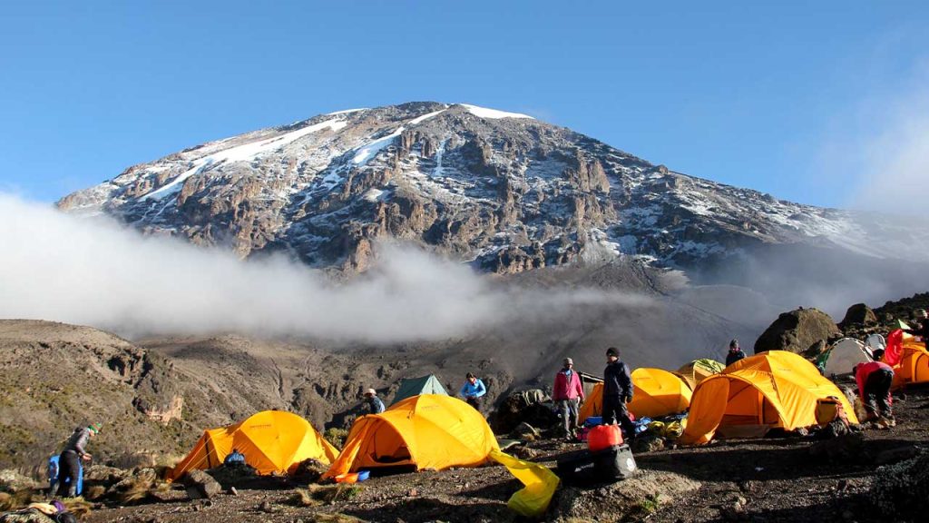
• Elevation (ft): 12,500ft to 13,000ft
• Distance: 10 km
• Hiking Time: 6-8 hours
• Habitat: Semi Desert
From the Shira Plateau, we continue to the east up a ridge, passing the junction towards the
peak of Kibo. As we continue, our direction changes to the South East towards the Lava
Tower, called the “Shark’s Tooth.” Shortly after the tower, we come to the second junction
which brings us up to the Arrow Glacier at an altitude of 16,000ft. We now continue down to
the Barranco Hut at an altitude of 13,000ft. Here we rest, enjoy dinner, and overnight.
Although you end the day at the same elevation as when you started, this day is very
important for acclimatization and will help your body prepare for summit day.

• Elevation (ft): 13,000ft to 15,000ft
• Distance: 9km
• Hiking Time: 8-10 hours
• Habitat: Alpine Desert
After breakfast, we leave Barranco and continue on a steep ridge passing the Barranco Wall,
to the Karanga Valley campsite. Then, we leave Karanga and hit the junction which connects
with the Mweka Trail. We continue up to the Barafu Hut. At this point, you have completed
the South Circuit, which offers views of the summit from many different angles. Here we
make camp, rest, enjoy dinner, and prepare for the summit day. The two peaks of Mawenzi
and Kibo are to be seen from this position.

• Elevation (ft): 15,300ft to 19,345ft (and down to10,000ft)
• Distance: 5 km ascent / 12 km descent
• Hiking Time: 7-8 hours ascent / 4-6 hours descent
• Habitat: Arctic
Very early in the morning (midnight to 2 am), we continue our way to the summit between
the Rebmann and Ratzel glaciers. You head in a northwesterly direction and ascend through
heavy scree towards Stella Point on the crater rim. This is the most mentally and physically
challenging portion of the trek. At Stella Point (18,600 ft), you will stop for a short rest and
will be rewarded with the most magnificent sunrise you are ever likely to see (weather
permitting). From Stella Point, you may encounter snow on your 1-hour ascent to the
summit. At Uhuru Peak, you have reached the highest point on Mount Kilimanjaro and the
continent of Africa. Faster hikers will see the sunrise from the summit. From the summit, we
now make our descent continuing straight down to the Mweka Hut camp site, stopping at
Barafu for lunch. You will want gaiters and trekking poles for the loose gravel going down.
Mweka Camp is situated in the upper forest and mist or rain can be expected in the late
afternoon. Later in the evening, we enjoy our last dinner on the mountain and a well-earned
sleep.

• Elevation (ft): 10,000ft to 5,400ft
• Distance: 10 km
• Hiking Time: 3-4 hours
• Habitat: Rainforest
After breakfast, we continue the descent down to the Mweka Park Gate to receive your
summit certificates. At lower elevations, it can be wet and muddy. Gaiters and trekking poles
will help. Shorts and t-shirts will probably be plenty to wear (keep rain gear and warmer
clothing handy).
From the gate, you continue another hour to Mweka Village. A vehicle will meet you at
Mweka village to drive you back to the hotel in Moshi.
the mountain. Overnight Mweka Camp.

You can send your enquiry via the form below.

Let’s Go 6 Days Climb Kilimanjaro Mountain via Machame Route

    No. Adult

    No. Child

    customer support
    Get in touch with us on Call. You can also send us any quick questions by getting in touch via WhatsApp.
    follow us
    Copyright © 2023  All Rights Reserved. Design by Habari Node

    Lost your password?

    Discover the real wild side of Africa on an adventure safari, choose an exciting tour that will ensure you have the holiday of a lifetime. Plan your exciting Tanzania Safari Tours with us and feel how adventure and expertise bring you satisfaction. High Peaks Expedition Ltd, is the best safari tour company in Africa specializing in African Safari Planing, Mountain Trekking and Beach Holidays tours.

    Address

    Arusha – Tanzania

    Phone

    Email

    Open chat
    1
    Need help?
    Hello,
    Can we help you?